McCree Cemetery

An Historic Cemetery in Dallas, Texas

McCree Cemetery

An Historic Cemetery in Dallas, Texas

McCree Cemetery

An Historic Cemetery in Dallas, Texas

The Restoration Project

Introduction

This report presents a historic context and archeological investigations of McCree Cemetery, a historic cemetery, located in Dallas, Texas.  The purpose of the investigations was to determine a chronological history of McCree Cemetery and the surrounding tracts of land.  The investigation consisted of a background literature review, an assessment of archival sources (aerial photographs and historic maps) and the excavation of three shovel tests on an east – west axis across the site to record the soil profiles.  The survey also investigated the possibility of graves placed outside of the modern cemetery boundary.

Versar, Inc. was contracted by Preservation Dallas in January 2014 to conduct an archeological survey and historical research on McCree Cemetery.  The project forms the basis of a restoration program of McCree Cemetery in the Lake Highlands neighborhood of Dallas, Dallas County, Texas.  The 2.6-acre site primarily consists of stone grave markers surrounded by overgrown vegetation with interspersed trees across the site and marking the cemetery boundary.  The restoration program’s goal is to record, preserve, and restore the cemetery monuments and establish guidance for the continued stewardship of McCree Cemetery.  The restoration of headstones is not part of the current effort; however, the survey conducted is intended to facilitate future restoration.

Cultural resources investigations were conducted by the staff of Versar, Inc. (Versar), including Principal Investigator Duane E. Peter, Historian Marsha Prior, and Archeologist Andrew Parkyn.  The environmental survey was conducted by Wildlife Biologist Chris Taylor.

Oral histories were conducted by Richland College students under the direction of professors Mr. Tim Sullivan and Mr. Clive Siegle.  As part of an enhanced honors course called “Finding Little Egypt,” students have been engaged in the investigation of the life of African American and White Dallasites from the Reconstruction and the Jim Crow period to the 1960s, as reflected in the story of the vibrant settlement known as Little Egypt.  As part of this course, students interviewed former inhabitants of the community.  On October 13, 2015, students conducted a group interview of Mr. George McCoy, Mr. Jerry McCoy, Ms. Joann McCoy, Mr. Sandy McCoy, Jr., and Ms. Gloria McCoy.  Because of the Little Egypt association with McCree Cemetery, the opportunity to use the information collected by the professors and their students offered a great opportunity to enhance the history included within the McCree Cemetery report.  Interviews were conducted by students Mr. Robbie Moore, Ms. Samra Tariq, Mr. Alexander Taylor, and Professor Tim Sullivan.  Transcripts of the oral histories are included in Appendix A, and the associated interview releases are included in Appendix B.

Project Area

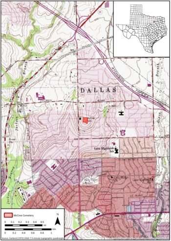
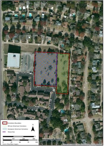
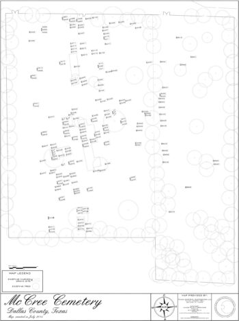
The project area is located southeast of the intersection of Estate Lane and Audelia Road in Dallas, Texas (Figure 1).  The cemetery is located at the intersection of the alleys for the homes along Estate Lane and Queenswood Lane.  The current cemetery measures approximately 2.6 acres with a segregated burial population:  the African American Cemetery to the east and the European American burials to the west (Figure 2).  A modern fence delineates the two cemeteries with separate, gated access to the north.  In 2015, Mr. James “Rusty” Brenner conducted an inventory of the existing markers in both sections of the cemetery.  One hundred fifty-eight (158) markers were recorded during the inventory (Appendix C), and locations were used to develop a site map of McCree Cemetery (Figure 3).

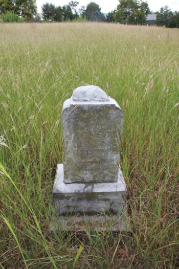
Fencing, gravestones, also known as grave markers, headstones, and tombstones, are the only built site features within McCree Cemetery.  The west side of the cemetery has a larger number of marked graves.  As depicted in Figure 3, the markers extend from the north end to the south end of the fence with a greater concentration towards the center of this section of the cemetery.  The east side of the cemetery has three to four sporadically defined rows.  It is possible that the east side of the cemetery contained organically homemade markers that have disappeared over time.  Both sides of the cemetery have a number of vacant sections where unmarked graves are likely present. 

There are a variety of grave markers within McCree Cemetery.  Every component of society used grave markers for commemorating the life of a departed loved one during this period.  It was common practice to use sculptured designs or symbols on limestone, marble, and granite.  Symbols typically denoted religious beliefs, fraternal organization association (Figure 4 and Figure 5), and other aspects of the life of the deceased.  Common sculpted reliefs include flowers, heaven’s gates with a star (see Figure 5), garden gates, Christian cross, lamb (Figure 6), grapevines, ivy, leaves, finger pointing upwards, clasped hands, dove, wreaths, open bibles, angels, ferns, decorative bands, columns, and draped fabric.  Many of these symbols are found in the professionally made gravestones at McCree.

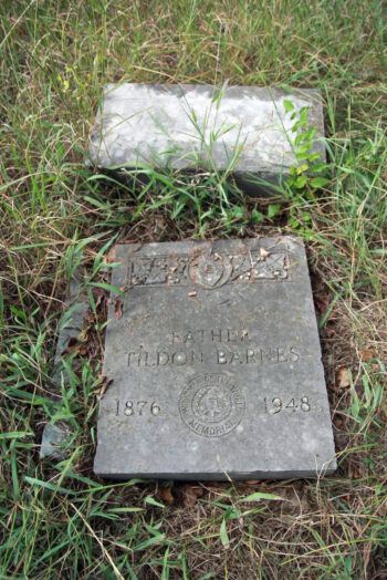
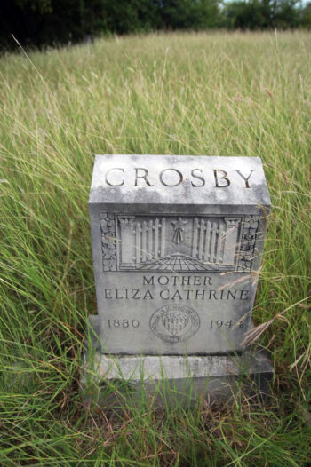
Woodman of the World and Supreme Forest Woodman Circle are among the organization associations represented at McCree Cemetery.  Woodman of the World provided burial insurance in the late 1800s and early 1900s.  Grave markers at McCree Cemetery feature the Woodman of the World memorial seal.  The phrase dum tacet clamat which means “Though silent, he speaks” is inscribed on the seal (see Figure 4).  Supreme Forest Woodman Circle was an auxiliary organization associated with Woodman of the World, and some grave markers at McCree Cemetery bear this seal (see Figure 5).  In addition, to symbols of religious beliefs and fraternal organizations, markers typically commemorated military service.  The grave marker of Jeff Hill (Section B, Row A, Grave 36) is an example of a marker commemorating military service.

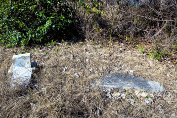
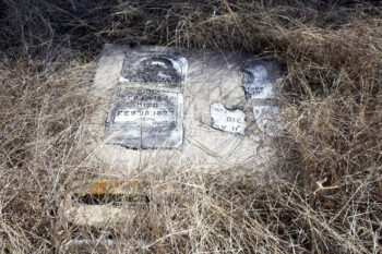
Grave markers at McCree Cemetery range in condition from poor to good.  Some markers are broken at the base and lying on the ground, others are broken in half (Figure 7), while a number have only the base remaining (see Figure 4).  Attempts to repair stones are evident.  These typically consisted of lying the grave marker in concrete (Figure 8).  The restoration of grave markers is not part of the current efforts at McCree Cemetery.  However, the current efforts are intended to facilitate future repairs.  Additional photographs of the grave markers at McCree Cemetery are located in Appendix E.

Figure 6. Grave marker with a lamb motif (note portion of the lamb is broken) (Section A, Row F, Grave 5).
Figure 1. Map showing the location of McCree Cemetery.
Figure 2. Location of McCree Cemetery with cemetery divisions.
Figure 3. 2015 inventory of McCree Cemetery by James “Rusty” Brenner.
Figure 4. Grave marker with Woodman of the World seal (Section A, Row H, Grave 2).
Figure 5. Grave marker with the Supreme Forest Woodman Circle seal and heaven’s gates with a star (Section A, Row G, Grave 7).
Figure 7. Grave stone broken and fallen over at McCree Cemetery (Section B, Row A, Grave 35 [marker on the left] and Section B, Row A, Grave 33 and 34 [marker on the right]).
Figure 8. Fallen grave markers set flat in concrete (Section A, Row M, Grave 50 [marker on the left] and Section A, Row M, Grave 51 [marker on the right]).

Archival Methods

Historical maps and aerial imagery were consulted to examine the development of the area around McCree Cemetery.  These historical resources included property maps, Dallas highway maps, and aerial photographs of the cemetery.  A GIS database was created with the digitized historic resources allowing comparison between mapping information and images.

Archival data was collected from a number of repositories and came from various sources.  Valuable information was collected at the Dallas/Texas History and Archives Division of the Dallas Public Library, Preservation Dallas, Dallas City Archives, online map sources at Degolyer Library (Southern Methodist University), and online newspaper data banks.  Other sources examined included City of Dallas telephone directories and the People’s Undertaking Day Books for the years 1910, 1915, and 1929 (the only years available).

Some of the most valuable data came from individuals with a long interest in cemetery research, descendants of those buried at McCree Cemetery, and those who lived near the cemetery.  Frances James, a researcher who has collected information on Dallas County cemeteries, graciously allowed access to her files on McCree Cemetery.  A number of descendants granted informal interviews, photographs, newspaper clippings, and other data.  Information shared by Opal Joplin, Sharon Cooper, Craig Sorrels, and Thomas Goforth was very helpful.  Ms. M’Layne Murphy, a Prigmore-Jackson-Lane descendant, was responsible for enriching this report with family photographs and invaluable data.  Another descendant, Ms. Lauren Madeley, shared family photographs that included that of the young Tommie Shepherd who is buried at McCree Cemetery.  Together, all the pieces of data shared by these individuals contributed to the completion of this study.

Fieldwork Methods

Archeological fieldwork consisted of three exploratory shovel tests.  The shovel tests were approximately 30 centimeters (12 inches) in diameter.  The soil from the shovel tests was not screened since the testing was only intended to characterize the soil profile across the site and examine any potential evidence for agricultural practices.  Shovel test locations were recorded with a submeter-accurate Trimble® GeoXH™ global positioning system (GPS) unit and soil profiles were documented on a standardized shovel test form.  Digital photographs were used to document significant vegetation changes, site conditions, and ground disturbances.  No artifacts were identified or collected during the investigation.  Shovel test forms were digitized and a master log produced (Appendix F).

Read the Recommendations from the survey here:

Preservation and Maintenance

Landmark Designation