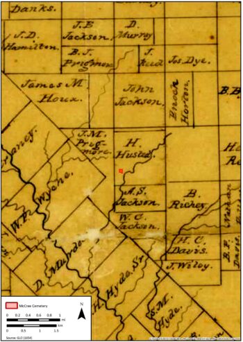
A desktop assessment was completed prior to fieldwork that collated documentary sources (maps and aerial photographs) into a GIS database for a chronological comparison with modern mapping information. The historic 1854 General Land Office (GLO) maps indicate that the tract of land that McCree Cemetery occupies was originally owned by (Harrison) H. Hustead (Figure 28) and still appears on the 1886 GLO maps, 20 years after the cemetery had been established. The lack of mention of the McCree’s ownership is likely the result of a relatively common practice of failing to record subdivisions of the original property in early land ownership maps.
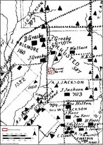
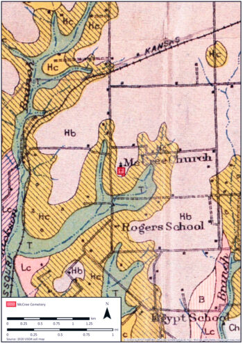
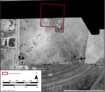
The first depiction of the McCree Cemetery appears on the 1900 Sam Street map with a series of crosses/gravestone markers and the word graveyard plotted on the southwest corner of the Hustead tract (Figure 29). The church associated with McCree Cemetery is first plotted on the 1920 USDA Dallas County soil map. The map plots the location of the cemetery with McCree Church immediately to the north of the cemetery (Figure 30). This confirms the church was built pre-1920 on the northern extent of the current cemetery boundary, but the exact date of construction is unknown. Local church groups used the building and the Rodgers Baptist Church congregation took over the building in the 1930s after their original church was razed to the ground by a fire. This has contributed to McCree Cemetery occasionally being incorrectly referred to as Rodgers, or Roger Cemetery (Wheat and Morgan 2002).
The 1930 City of Dallas aerial photograph is the first aerial photograph of the cemetery (Figure 31). Unfortunately the flightpath clipped the northern portion of the cemetery; therefore, the church is not visible in the image. However, the church is visible in the 1938 Tobin aerial photograph as a small rectangular structure (Figure 32). A roadway runs east-west up to the church and cemetery but low-lying clouds obscure the cemetery apart from the western boundary.
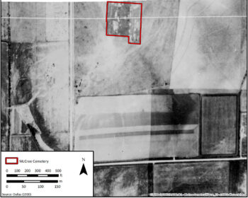
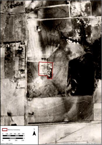
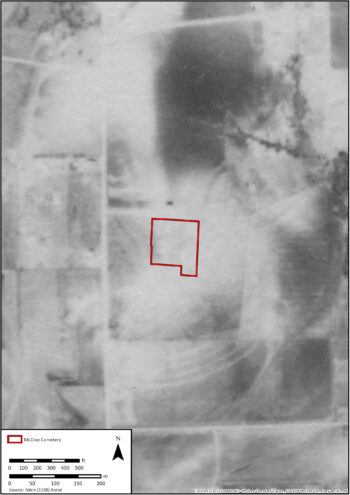
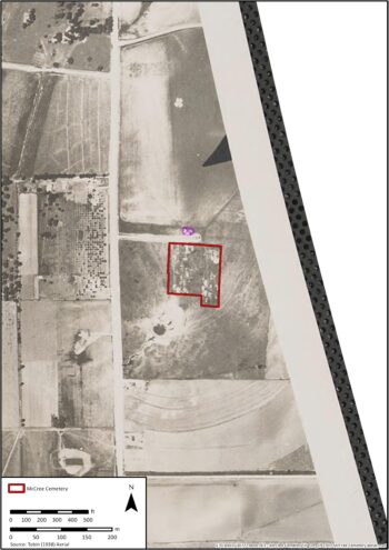
The 1945 USDA aerial photograph shows a series of sub rectangular blocks with an east-west alignment immediately to the north of the cemetery. The 1945 photograph is significant for the 1950 Dallas Morning News (discussed previously) suggested the church had been destroyed by fire circa 1945. The low resolution of the photograph makes it difficult to clearly distinguish structural components, but this could indicate the burned remains of the church (Figure 33). The church building may have not been completely removed after the fire as sub-rectangular structures are visible in the vicinity of the church on the 1949 Lloyd M. Long aerial photograph (Figure 34).
A partial aerial photograph of the cemetery from the 1952 USGS aerial photograph reconnaissance (again missing the northern portion of the site) shows evidence for the berm / path to the west of the cemetery that is still visible on the ground today (Figure 35 and Figure 36).
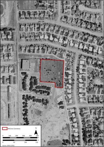
From 1957–1968, the area around McCree Cemetery was heavily developed by a mix of commercial and residential properties. The 1968 USGS aerial photograph shows the cemetery completely encompassed by residential properties to the north, south, and east, and the Southwestern Bell Building to the west of the cemetery (Figure 37). The original road leading to the church and cemetery is still visible in the 1968 aerial photograph but has subsequently been grassed over. The limestone fragments that made up the road material are still partially visible on the ground surface. The current access road at the back of the residential properties (to the north of the cemetery) was established before 1968 as seen in the USGS aerial. Based on the evidence from the 1945 and 1949 aerial photographs, it is likely that church would be located in the back garden of one of the current residential properties and the current access road (Figure 38).
Figure 31. Location of McCree Cemetery on a 1930 City of Dallas aerial photograph.
Figure 33. Location of McCree Cemetery on a 1945 USDA aerial photograph.
Figure 35. The berm running parallel with the western boundary fence may have stopped soil creep down slope.
Fieldwork
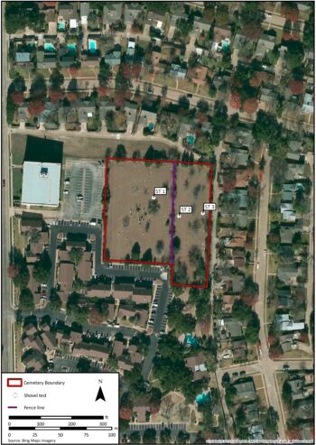
The shovel tests were located across an east–west axis of the cemetery (Figure 39). One shovel test was dug to the east of the apex of the hill in the European American portion of the cemetery. It was decided not to dig an additional shovel test on the western boundary due to the landscaped berm located there. The shovel test showed a greater depth of top and sub soil in the European American cemetery with the shovel test terminating at 60 cm in depth. The upper stratum in the soil profile consisted of a thin (0–8 cm) very dark grayish brown (10YR 3/2) silty clay with organic material and a dense root mat. Underlying the root mat (8–44 cm) was a dark brown (10YR 3/3) clay A horizon with krotovina / bioturbation disturbance (2–4 mm in diameter). The B horizon (44–57 cm) was a yellowish brown clay (10YR 5/4) with small pieces of calcium carbonate (2–4 mm in diameter). The calcium carbonate increased in diameter with depth (up to 2 cm in diameter). Within the B horizon (57–60 cm) calcium carbonate nodules made up 25 percent of the soil composition.
Two additional shovel tests were dug on the western and eastern boundaries of the African American cemetery. The shovel tests in the African American portion of the cemetery showed a shallower depth of soil deposition with the two shovel tests terminating at ≤47 cm. The upper stratum of the western shovel test (0–17 cm) consisted of a pink (7.5YR 7/3) clay with brown (7.5YR 5/3) mottling and limestone pieces. The B horizon (17–45 cm) was a brown (7.5YR 5/3) silty loam with ≤20 per limestone fragments 2-3 cm in diameter. The limestone increased in diameter (≥5 cm) and in density (20–50% of the soil composition) at 45–47 cm. The eastern shovel test’s upper stratum (0–15) was a brown (10YR 4/3) silty clay with calcium carbonate pieces 2–6 mm in diameter starting at 13 cm. The B horizon (15–46 cm) was a brown (10YR 5/3) silty clay with the proportion of limestone (10–20%) increasing to 70–80 percent limestone parent material between 44 and 46 cm.
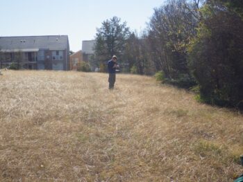
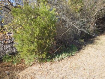
The vegetation surrounding the site may suggest that grave plots are situated close to the boundary of the cemetery. Iris, crepe myrtle, and juniperus trees (eastern red cedars and moonglow juniper) are planted along the boundary of the site. These plants have had a long association with death and cemeteries; the planting of specific types of trees and plants around burials has a pagan origin, but has long been established and accepted in Christian beliefs (Jordan 1984, 28). Plants associated with Christian burials are frequently located around the edges of cemeteries (Figure 40) or to demarcate individual grave plots as seen at McCree Cemetery (Figure 41). Two trees were recorded with a GPS in the field to plot their locations. These correlate with two of the larger trees identified in the 1968 aerial and indicate the land has been largely unmodified for approximately 50 years. No evidence for agricultural land use could be identified in the shovel tests that were excavated across the cemetery.
A small berm runs approximately north-south and parallel to the western boundary of the cemetery and is visible in the 1949 Lloyd M. Long aerial photograph of the area (see Figure 34). The narrow berm may be a boundary footpath or could possibly act as an erosional control measure for the western limits of the site (see Figure 35).
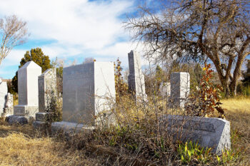
Evidence for erosional problems on the site were identified by a number of hollows on the African American portion of the cemetery that showed recent indications of erosion as the vegetation had been denuded from the hollows. The hollows may indicate sunken unmarked graves that have eroded out and vegetation has failed to stabilize the ground surface.
The majority of interments took place prior to 1960, based on the dates of death on grave markers (Wheat and Morgan 2002). This was before the surrounding neighborhoods filled in around the cemetery as shown by the 1950s aerials and the Dallas Central Appraisal District information (Dallas Central Appraisal District 2015). The last planned interment at the cemetery probably took place in 2002 but the reference refers to a burial ‘[that] will take place later at McCree Cemetery’ (Frank Patrick 2014). The location of iris and juniperus trees on the western cemetery boundary suggests that burials are located immediately adjacent to the fence line of the cemetery. A visual inspection of the planted border showed no evidence for eroding grave plots on the eastern side. The shallow depth of decaying bedrock in the easternmost shovel test also indicates that the area to the east was not particularly ideal for excavating burial shafts. The southern boundary of the cemetery is bordered by a parking lot for an adjacent apartment complex. The prior excavation of the area to a depth of 4 feet or more apparently did not encounter graves; therefore, it is considered unlikely that the area contains graves.
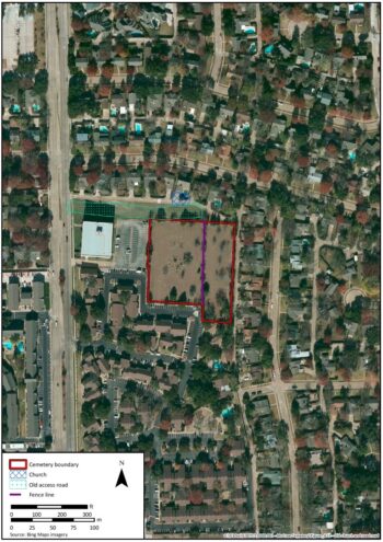
The greatest potential for unmarked burials is between the northern boundary of the cemetery and the former location of the church. Historic accounts suggest the church and cemetery once covered approximately 3.6 acres. An access road running east from Audelia Road separated the church and cemetery (see Figure 38). Later, residential and commercial development encroached on the land previously occupied by the church, reducing the plot size to 2.6 acres. Due to the reduction in plot size, it is recommended that any future construction/redevelopment on the north side of McCree Cemetery be carefully monitored for burials and possible foundation remains of the church.
Figure 28. Location of McCree Cemetery on the 1854 GLO map.
Figure 22. Location of McCree Cemetery on the 1900 Sam Street map.
Figure 30. Location of McCree Cemetery on the 1920 USDA Dallas County soil map.
Figure 32. Location of McCree Cemetery on a 1938 Tobin aerial photograph.
Figure 34. Location of McCree Cemetery on a 1949 Lloyd M. Long aerial photograph.
Figure 36. Location of McCree Cemetery on 1952 USGS aerial photograph.
Figure 37. Location of McCree Cemetery on 1968 USGS aerial photograph.
Figure 38. Probable locations of McCree Church and the old access road plotted on modern imagery.
Figure 39. Location of McCree Cemetery with shovel test locations.
Figure 40. Juniperus trees and irises planted along the western boundary of McCree Cemetery.